


Air New Zealand inks direct partnership with ChatGPT maker OpenAI, pair create virtual customers https://www.byteseu.com/1221831/ #air #artificial #before #being #ChatGPT #create #customers #deal #direct #focus #group #human #including #inks #Intelligence #maker #multiple #new #NewZealand #OpenAI #pair #partnership #products #Projects #services #signed #using #VIRTUAL #with #Work #zealand

Administered by:
#using
4 posts4 participants1 post today

Using MacBook's trackpad as digital weighing scale

GitHubGitHub - KrishKrosh/TrackWeightContribute to KrishKrosh/TrackWeight development by creating an account on GitHub.

Breaking down the St. Louis Cardinals 2025 draft, using Viva El Birdos top comments https://www.rawchili.com/mlb/190311/ #Baseball #birdos #Breaking #Cardinals #comments #down #draft #el #FrontPage #Louis #MLB #StLouisCardinalsSabermetricsAnalysis #StLouisCardnalsMlbDraft #St. #St.Louis #St.LouisCardinals #StLouis #StLouisCardinals #the #top #using #viva #VivaElBirdosCommunityCommentsPollsReactionsProjections

https://www.alojapan.com/1325715/explore-nuevo-tokyo-in-beat-em-up-roguelike-mexican-ninja/ Explore Nuevo-Tokyo in Beat-’em-up Roguelike Mexican Ninja #beat #crime #gameplay #mexican #narkuza #news #ninja #nuevo #rebel #roguelike #Tokyo #TokyoNews #using #東京 #東京都 Some of the most dreaded crime organisations have joined forces, as the Narcos and the Yakuza team up and create the powerful Narkuza clan. Now, Nuevo-Tokyo is their criminal playground, and it’s up to rebel groups to reclaim the city… this is where Mexican Ninja come
Analysing Roman itineraries using GIS tooling
https://link.springer.com/article/10.1007/s12520-025-02175-w
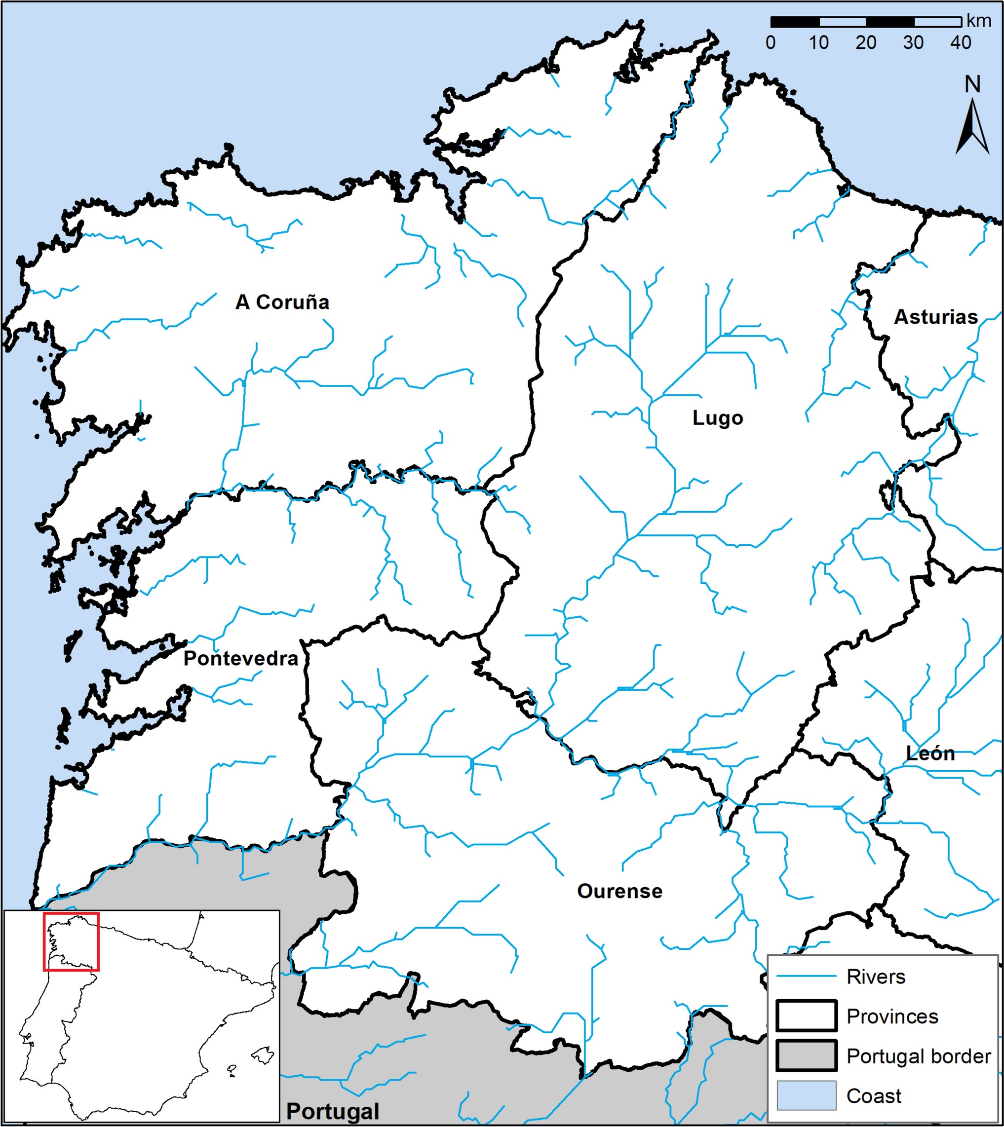
SpringerLinkAnalysing Roman itineraries using GIS tooling: the case of the road XIX (mansions from Tude to Luco Augusti) - Archaeological and Anthropological SciencesReconstruction of the Roman road network must be approached from different methodologies of multidisciplinary character. Once the traditional approaches have been exhausted without achieving a historiographical consensus, the problem may appear insurmountable. However, leveraging Geographic Information Systems (GIS) provides an avenue for re-evaluating existing proposals and suggesting more fitting layouts. This can be accomplished through a meticulous analysis that incorporates topographic and non-Euclidean correlations; allowing a more nuanced and accurate understanding of the subject matter than conventional methods might offer. In this context, the aim of this article is to discuss intriguing research points. But also emphasize the importance of multidisciplinary and multi-proxy studies in relation with the Roman terrestrial networks. We explore a case study in the Galician territory, where we have detected methodological shortcomings reconstructing the route of the XIX road: Item Bracaram Asturicam. One of the sections, from Tude to Luco Augusti, has aroused a greater debate, based on several basic problems: (1) the identification of the mansions, (2) the lack of consensus in the measurements of the distances, (3) the miles referred to in the classical sources, and (4) the complex orography of this territory. To propose answers and theories, that may solve the current problems of the description of this route of the XIX road, a multi- proxy approached methodology is proposed. Thus, by applying Geographic Information Systems techniques, we will be able to calculate the optimal path, and compare the results with historical data and archaeological evidence.
The Seattle Mariners are using pinch hitters more than any other team https://www.rawchili.com/mlb/159165/ #any #are #Baseball #ExcludeFromStnVideo #FrontPage #hitters #landing #lookout #Mariners #more #other #pinch #Seattle #team #than #the #TheMoreYouKnow #using

MLB · The Seattle Mariners are using pinch hitters more than any other team - MLBThe Mariners are bad at pinch hitting, and they do it more than anyone.
Get the location of the ISS using DNS
https://shkspr.mobi/blog/2025/07/get-the-location-of-the-iss-using-dns/

Terence Eden’s Blog · Get the location of the ISS using DNS
More from  Terence Eden
Cops in [Spain] think everyone using a Google Pixel must be a drug dealer
https://www.androidauthority.com/google-pixel-organized-crime-preferred-phone-3573578/
#HackerNews #Cops #in #Spain #think #everyone #using #a #Google #Pixel #must #be #a #drug #dealer
drugdealing #allegations #Spain #GooglePixel #lawenforcement #technews

Android Authority · Cops in this country think everyone using a Google Pixel must be a drug dealer (Updated)Pixel phones are criminals' top pick in Spain's Catalonia for their strong security and mod-friendly design.
Using the Internet without IPv4 connectivity
https://jamesmcm.github.io/blog/no-ipv4/
#HackerNews #Using #the #Internet #without #IPv4 #connectivity
internet #connectivity #ipv4 #technology #networking #future
jamesmcm.github.ioUsing the Internet without IPv4 connectivityA technical blog about Rust, Linux and other topics.
Using an $8 smart outlet to avoid brainrot
https://www.neilchen.co/blog/kasa
#HackerNews #Using #an #$8 #smart #outlet #to #avoid #brainrot
smartoutlet #brainrot #productivity #techhacks #homeautomation
www.neilchen.cokasa
Washington Nationals brass needs to stop using 2019 as a crutch https://www.rawchili.com/mlb/115699/ #a #as #Baseball #brass #crutch #federal #FrontPage #MLB #nationals #needs #stop #to #using #washington #WashingtonNationals #WashingtonNationals
Using computers more freely and safely (2023)
https://akkartik.name/freewheeling/
#HackerNews #Using #computers #more #freely #and #safely #(2023) #computers #safety #freedom #technology #HackerNews
akkartik.nameUsing computers more freely and safely
FioBit: Best Cryptocurrency Faucets in 2025-Earn Passive Income Online Using Free Bitcoin Cloud Mining Sites Without Investment https://www.byteseu.com/?p=1070735 #2025Earn #best #bitcoin #Cloud #Crypto #CryptoCurrency #Faucets #FioBit: #free #in #income #investment #mining #online #Passive #sites #using #without
Using Ed(1) as My Static Site Generator
https://aartaka.me/this-post-is-ed.html
#HackerNews #Using #Ed(1) #as #My #Static #Site #Generator #StaticSiteGenerator #Ed1 #HackerNews #TechBlog #WebDevelopment
Artyom BologovUsing ed(1) as My Static Site GeneratorYou can tell I'm an ed fan. Not only do I use it for esoteric challenges or compiler building, it also is my new SSG (Static Site Generator.) So here's how it works:

NFL salary cap: Browns GM Andrew Berry among those using loopholes the NFL might want to close https://www.rawchili.com/nfl/93573/ #among #andrew #berry #browns #by #cap #cleveland #ClevelandBrowns #ClevelandBrownsNews #ClevelandBrownsSalaryCapContracts #ClevelandBrowns #close #dawgs #Football #FrontPage #gm #loopholes #might #nature #NFL #salary #the #those #To #using #want
Using lots of little tools to aggressively reject the bots
lambdacreate.com(lambda (x) (create x))
Beating Google's kernelCTF PoW using AVX512
anematode · Beating the kCTF PoW with AVX512IFMA for $51kPoW is gone 🦀🦀

https://www.europesays.com/uk/134910/ Calgo Launches Mobile App to Support Distributed AI Computing Using Idle Device Resources #AI #app #Calgo #Computing #Device #Distributed #Idle #launches #Mobile #Resources #support #Technology #to #UK #UnitedKingdom #using
Using elliptic curves to solve a math meme
#HackerNews #Using #elliptic #curves #to #solve #a #math #meme #mathmemes #ellipticcurves #mathematics #problem-solving #HackerNews