techhub.social is one of the many independent Mastodon servers you can use to participate in the fediverse.
A hub primarily for passionate technologists, but everyone is welcome

Administered by:

Server stats:

4.7K
active users

#postgis

4 posts4 participants0 posts today

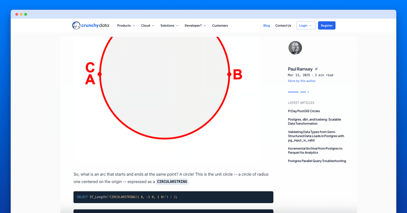
Learned a lot in the past to weeks in the GIS domain. Finally came up with a good and performant solution for "adding privacy" to GPS traces by stenciling out private spots like overnight stays and adding smoothing - all in SQL.

Green is the precise version. Pink is coarse and red is coarser and both without overnight stops.

Im Juli macht die @FOSS_Acasdemy Sommerpause. Ab August geht's weiter mit vielen spannenden Open-Source-GIS-Schulungen!

Sichern Sie sich jetzt einen der noch verbleibenden Plätze.

Die FOSS Academy bietet Kurse rund um #Mapbender #QGIS #MapServer #PostGIS #GeoServer #ALKIS 5-tägiger Kompaktkurs & mehr.

Bis zu 6 Wochen vor Schulungsbeginn erhalten Sie 10% Frühbucherrabatt!

foss-academy.com/

Jetzt anmelden!
#FOSSGIS #GIS #GEOSPATIAL #FOSS4G #OSGeo #QGIS

Something like 10+ years ago when I was looking into #postgis , #pgrouting and other related stuff I had an idea (that's been bouncing around my skull since) for a "tripplanner for goths" that would be using DEM(my stuff) and GRASS's r.sunmask or similar, turning the raster via vector to costs and routing with that.

Now somebody built it.
mastodon.social/@sfkeller/1147

The usual, shortest route compared to the “vampire route” from Zurich main station to the Polyterrasse at ETH
MastodonStefan F. Keller (@sfkeller@mastodon.social)Attached: 1 image New blog post about "The coolest way to find shaded paths: Vampire routing on routing.osm.ch". See https://sosm.ch/the-coolest-way-to-find-shady-paths-vampire-routing-on-routing-osm-ch/ #OSMinside #OpenStreetMap #Routing #UrbanHeat #SOSM
Replied in thread

A l'heure où l'on parle de souveraineté sur l'ensemble des services numériques, l'information géographique a atteint un niveau de maturité incroyable.
La gestion des données spatiales de référence de Finlande bascule sur des technologies open source et libres. #QGIS et #postgresql #postgis au moins au menu.
L'ouverture des formats de données, l'intéropérabilité, la mutualisation sur les outils avec les autorités publiques sont mises en avant :

positio-magazine.eu/2025/06/fi

Positio · Finland Launches Modern Topographic Data System – Built on Open-Source QGIS | PositioThis new open-source based system enables more efficient and up-to-date maintenance of the national topographic data and the production of general map products.

@avlcharlie I truncated the error message to fit in the 500 character limit of chaos.social. This failure probably needs a longer post for context; terse version follows:
I found I can drag a layer in QGis to my local #PostGIS database and drop it into the a DB instance. Poof! The data goes from a KML or whatever, into a fully-formed PostgreSQL object.
Until now, when the layer came from ESRI formatted x/y content. I *think* the CRS map projection being over 1000000 hit a bump. To be continued.

MDS in geo: An example with Mapillary: Two articles by Michaël Galien on @geotribu showcase how to leverage a Modern Data Stack (#MDS) for processing geospatial data from #Mapillary. The workflow features #dbt, Apache #Airflow, #PostGIS, #SQL, and #Python, highlighting a robust...
spatialists.ch/posts/2025/06/0 #GIS #GISchat #geospatial #SwissGIS

Spatialists – geospatial newsMDS in geo: An example with Mapillary – Spatialists – geospatial news
More from Spatialists

🆕 New technical article (in English): Efficient workflow to load and explore ENC (S-57) nautical charts in PostGIS and QGIS.

🔍 Overview of the S-57 format structure
⚙️ Automated import with ogr2ogr and batch scripts
🧩 PostGIS optimization: triggers, stored procedures & indexing
🗺️ QGIS-ready in minutes for fast cartographic exploration

📘 Read the article here 👉sigterritoires.fr/index.php/en

#QGIS#PostGIS#S57