techhub.social is one of the many independent Mastodon servers you can use to participate in the fediverse.
A hub primarily for passionate technologists, but everyone is welcome

Administered by:

Server stats:

5.3K
active users

#Landslides

0 posts0 participants0 posts today

#Malaysia #landslides #NaturalDisasters

'The Batang Kali landslide on December 16, 2022, left an indelible mark on Malaysia’s history, claiming 31 lives — 13 of them children.

What began as personal grief has now evolved into a powerful platform for healing and advocacy...

The website serves as a digital memorial where survivors reclaim their narrative and continue to demand accountability for what they argue was more than just an unfortunate natural disaster.'

malaymail.com/news/malaysia/20

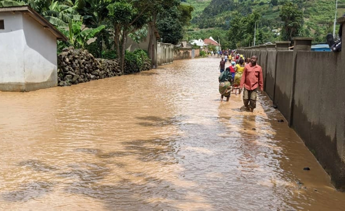
Good news from PBOT!

(Monday, Feb. 24, 2025) – The Portland Bureau of Transportation reopened NW Cornell Road and a lane on NW Thompson Road earlier than expected, after clearing landslide debris today.

Both roads were impacted by landslides late Sunday afternoon, that led to closures that were expected to impact the Monday morning commute and potentially last all day.

NW Cornell Road was reopened before noon today. It was closed to all travelers, between NW Skyline and NW Thompson Road. PBOT crews removed 30 cubic yards of material in two dump truck loads.

The westbound travel lane on NW Thompson was reopened before 2 p.m. today. It had been closed from NW Pinnacle Drive to NW Miller Road. This slide is at 8450 NW Thompson, the road just west of the intersection of NW Thompson Road and NW Skyline Blvd. PBOT crews removed 38 cubic yards of debris in 2 and a half dump truck loads.

NASA Radar Imagery Reveals Details About Los Angeles-Area Landslides. Landslides on Palos Verdes peninsula have been moving rapidly in last two years. NASA airborne radar called UAVSAR flies on piloted NASA planes and measures displacements of the ground surface using InSAR analysis. We requested flights in three directions to map motion of landslides on the Palos Verdes peninsula next to Los Angeles. #NASA #NASA_JPL #InSAR #radar #landslides

jpl.nasa.gov/news/nasa-radar-i

NASA Jet Propulsion Laboratory (JPL)NASA Radar Imagery Reveals Details About Los Angeles-Area LandslidesAnalysis of data from NASA radar aboard an airplane shows that the decades-old active landslide area on the Palos Verdes Peninsula has expanded.

The Case for Letting Malibu Burn
Bushfires and sprawl: Man-made catastrophes and cultural narratives

The lethal mixture of home ownership and the bush: Neighborhoods on fire.
"Since 1993. almost half of California’s new homes have been built in fire hazard areas...Commercial greed over common sense and the social good."

The aristocratisation of the coast
"In a feverish buying and selling of land, the coast has become utterly transformed and unrecognizable. Each succeeding house, bigger and grander, takes the view of its neighbors in a kind of unbridled competition.… Once lost, paradise can never be regained.… Developers have bulldozed the Santa Monicas beyond recovery."
>>
Mike Davis, Ecology of Fear: The Case for Letting Malibu Burn. 1998
longreads.com/2018/12/04/the-c

Ecology of Fear: Mike Davis’ history of LA and natural disaster is re-read whenever fire rages in California >>
theconversation.com/ecology-of
#bushfires #fires #firestorms #sprawl #housing #suburbs #mansions #OverDevelopment #coast #NSW #destruction #disasters #gridlocked #roads #highways #floods #landslides #WUI #FossilFuels #Biodiversity #Holocene #folly

Longreads · The Case for Letting Malibu BurnBy Longreads
Continued thread

"#Indonesia and #Malaysia, the world’s two biggest palm oil producers, have been hit by deadly #landslides and power outages, while #Thailand and the #Philippines are facing severe #floods in some regions, according to government weather agencies. Elsewhere, #Singapore received about half of its normal November rainfall on a single day over the weekend."

bloomberg.com/news/articles/20

Bloomberg · Heavy Rains in Southeast Asia Flood Farms and Force EvacuationsBy Eko Listiyorini

Linking Inca Terraces With Landslide Occurrence In The Ticsani Valley, Peru
--
doi.org/10.3390/geosciences141 <-- shared paper
--
[takes me back to my engineering geology days in the Southern Hemisphere, including my thesis – with a healthy dose of spatial analysis and modeling – and all with a specific use; what is not to like?]

This is very interesting: mobility of seismically triggered landslides (noisily) increases with size below a certain threshold, but above it mobility decreases with size.

My first (ignorant) hypothesis is that it's some sort of interaction between the seismic wave field and the failure surface...

eos.org/thelandslideblog/the-m

Eos · The mobility of landslides triggered by earthquakesBy Dave Petley

HT @northernlights

‘The land is tearing itself apart’: life on a collapsing #Arctic isle

On #Qikiqtaruk, off Canada, researchers at the frontier of #ClimateChange are seeing its rich ecology slide into the sea as #MeltingPermafrost ice leaves little behind

“It’s one thing to think about what the changes mean to us, but I can’t imagine the fear and stress the animals feel as everything changes so fast. We’re supposed to be the guardians of the land. But we’ve let them down.” - Richard Gordon.

By Leyland Cecco, on Herschel Island–Qikiqtaruk
November 21, 2024

"Armed with a fleet of drones and working closely with Indigenous Inuvialuit rangers, the team has revealed a rapid reshaping of the tundra with little precedent. As they race to understand what those changes might mean, a combination of rising seas, landslides and flooding mean the landscape is literally collapsing around them, making it harder to study an island that reflects the tumultuous future of the western Arctic."

theguardian.com/environment/20

The Guardian · ‘The land is tearing itself apart’: life on a collapsing Arctic isleBy Leyland Cecco