


One of the main outputs of the @earthmonitororg project is the ARD ICESat2 / GEDI (pnts) data set, an ensemble Digital Terrain model and some 15+ #geomorphometry variables (at 6 nested resolutions 30, 60, 120, 240, 480 and 960 m resolutions). Read more about the #GEDTM30 here: https://doi.org/10.7717/peerj.19673
just published in @PeerJ
Built using @gdal @whiteboxgeo @grassgis
Stay tuned for the upcoming v1.1 with more data, less artifacts, easier access; to register for updates: https://github.com/openlandmap/GEDTM30
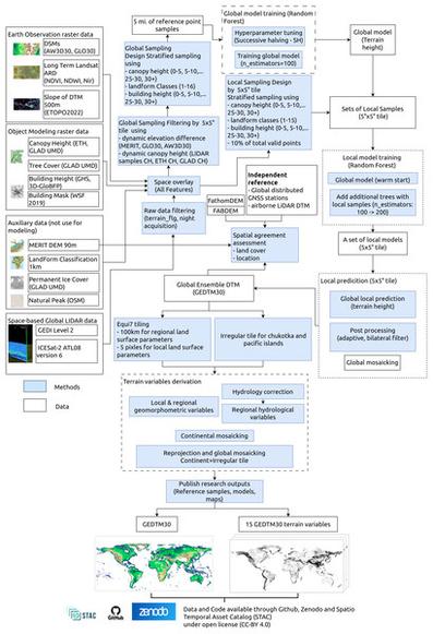
PeerJGEDTM30: global ensemble digital terrain model at 30 m and derived multiscale terrain variablesProduction and validation of an open global ensemble digital terrain model (GEDTM30) and derived terrain variables at 1 arc-s spacing grid ( $\sim$∼ 30 m spatial resolution) is described. Copernicus DEM, ALOS World3D, and object height models were combined in a data fusion approach to generate a globally consistent digital terrain model (DTM). This DTM was then used to compute 15 standard terrain variables across six scales (30, 60, 120, 240, 480 and 960 m). A global-to-local transfer learning model framework with 5° × 5° tiling leveraged globally distributed lidar datasets: ICESat-2 ATL08 (best-fit terrain height) and GEDI02 (lowest mode elevation), totaling over 30 billion training points. A global model was initially fitted using ICESat-2 and GEDI, followed by locally optimized models per tile, ensuring both global consistency and local accuracy. Independent validation shows that GEDTM30 reduces Copernicus DEM RMSE by about 25.4% in built-up areas, 10.0% in regions with 10–50% tree cover, and 27.3% in areas with over 50% tree cover. Compared to state-of-the-art DTMs (MERIT DEM, FABDEM and FathomDEM), GEDTM30 achieves the lowest vertical errors when assessed with GNSS station records, yielding a standard deviation of 7.77 m, an RMSE of 10.69 m, and a mean error of 7.34 m. FathomDEM exhibited the lowest vertical RMSE when validated against independent reference DTMs. GEDTM30 was further used to generate multiscale variables of topography and hydrology through an optimized tiling workflow ( $\sim$∼ 800 tiles of 600 × 600 km with $\sim$∼ 16% overlap) based on the Equi7 grid system. The entire workflow was implemented in Python using GDAL and Whitebox Workflows. Visual inspection confirmed the absence of boundary artifacts and the preservation of hydrologic connectivity. The tiling-based implementation significantly reduces computational costs of generating large-scale DTMs and derived terrain variables. The GEDTM30 dataset and code are publicly available as Cloud-Optimized GeoTIFFs via Zenodo and the OpenLandMap STAC. Further fusion with local lidar-based DTMs and national DTMs is recommended to enhance local accuracy and level of detail.


 Greg Cocks