https://www.europesays.com/1964606/ WVNCC opens new business center, offering hands-on entrepreneurship training #america #AppliedScience #AssociateDegree #business #BusinessCenter #Entrepreneurship #HandsOnTraining #OhioValley #SmallBusiness #UnitedStates #UnitedStatesOfAmerica #US #USA #WVNCC
Recent searches
Search options
#appliedscience
Digital Transformation In GIS & Hydrology
--
https://youtu.be/hz4g491uync?si=2g8TV9kipgWltT6i <-- shared video interview
--
It was a pleasure to do this interview...
[Note: this was NOT as a representative of my employer, rather as a professional in this area]
#GIS #spatial #mapping #usecase #opendata #appliedscience #alldataisspatial #evolvingsystems #water #hydrology #video #interview
@BimTube | @GregCocks
How a fox skull shape conquers the snow
https://www.npr.org/2024/12/27/nx-s1-5233363/how-a-fox-skull-shape-conquers-the-snow
* pointy shape of fox's snout makes it particularly adept at diving headfirst into snow
Effect of skull morphology on fox snow diving
https://www.pnas.org/doi/10.1073/pnas.2321179121
Penetration of fox & human skulls into granular matter: Oversimplifying a complex phenomenon?
https://www.pnas.org/doi/10.1073/pnas.2410281121
Secrets Of Snow-Diving Foxes
https://www.npr.org/sections/krulwich/2014/01/03/259136596/youre-invisible-but-ill-eat-you-anyway-secrets-of-snow-diving-foxes
https://www.youtube.com/results?search_query=Fox+Dives+Headfirst+Into+Snow
"Can you construct a constant-width body in any dimension that is exponentially smaller than the ball?"

3D Elevation [3DEP] Data Crucial To Supporting The Nation’s Infrastructure And Maintaining Economic Security
--
https://www.usgs.gov/news/featured-story/3d-elevation-data-crucial-supporting-nations-infrastructure-and-maintaining <-- link to article
--
https://www.usgs.gov/3d-elevation-program <-- USGS 3DEP home page and access to open data
--
https://www.usgs.gov/3d-national-topography-model/fy24-3dep-data-collaboration-announcement-dca-selected-projects <-- 3DEP Data Collaboration Selected Projects
--
#GIS #spatial #mapping #LiDAR #opendata #USA #elevation #remotesensing #3DEP #topography #economy #economicbenefits #economicsecurity #infrastructure #national #3d #pointcloud #usecase #appliedscience #business #construction #IfSAR #bareearth #datacollaboration
@USGS
History of GIS - Video – CGIS, The First Operational GIS, Canada [1967]
--
https://youtu.be/3VLGvWEuZxI?si=dp64Np3FhyMSTirt <-- shared video
--
https://en.wikipedia.org/wiki/Canada_Geographic_Information_System <-- Canada GIS wiki page
--
“Early [1967] video description of the first operational GIS, the Canada GIS. The "father of GIS," Roger Tomlinson is highlighted. It is also an excellent description of how GIS operates today although the technology is considerably more advanced than when CGIS was first developed…”
#GIS #spatial #mapping #topology #cartography #spatialanalysis #gischat #appliedscience #solutions #history #canada #RogerTomlinson #CGIS #CanadaGeographicInformationSystem #CanadaLandInventory #canadaday
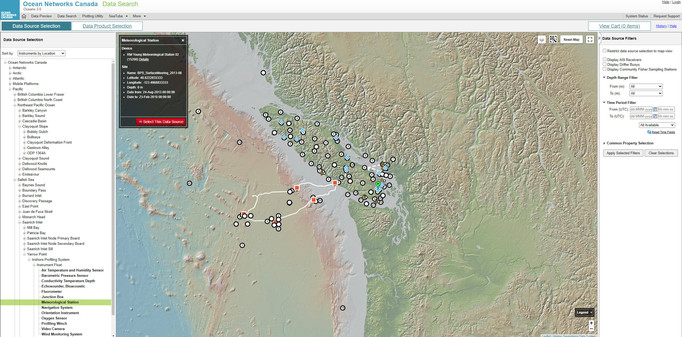
Ocean Networks Canada (ONC) Data Portal
--
https://data.oceannetworks.ca/home <-- Ocean v3.0 Data Portal
--
#GIS #spatial #mapping #Canada #hydrospatial #data #dataportal #OceanNetworksCanada #ONC #marine #ocean #research #fisheries #economics #climatechange #oceanobservation #coast #coastal #boology #chemistry #geology #weather #metrology #usecase #appliedscience #infrastructure #sensors #FirstNation #indigenous #monitoring #training #education #canadaday
@Ocean_Networks
The 3D National Topography Model Call For Action—Part 1. The 3D Hydrography Program [USGS publication]
--
https://doi.org/10.3133/cir1519 <-- shared USGS Circular 1519
--
https://www.usgs.gov/3DHP <-- 3DHP home page at the USGS
--
https://hydro.nationalmap.gov/arcgis/rest/services/3DHP_all/MapServer <-- open data WMS for 3DHP, WFS to follow soon
--
[awareness: this is my primary project at the USGS]
#GIS #spatial #mapping #water #hydrology #USGS #3dhp #EDH #elevationderivedhydrography #3DHydrographyProgram #NHD #WBD #NHDPlusHR #nation #USA #nationwide #usecase #appliedscience #economicbenefits #planning #monitoring #decisionmaking #informeddecisions #3d #xyz #waterbody #stream #river #flowline #lake #network #routing #opendata #3dtnm #topography #internetofwater #infostructure
@USGS
Let's be clear about one thing here: The Scientific Method is: Theoretical Proposal, Experimentation, Undisputed Factual Result (Applied Science) - Besides that, is guesswork.
#science #appliedscience #scientificmethod #observation #evidence #reasoning #criticalthinking #noguessing
Greg Cocks - Digital Transformation in GIS and Hydrology [BimTube vodcast]
--
https://youtu.be/hz4g491uync?si=-zIsfodi-l-kYe9W <-- link to BimTube vodcast
--
[speaking as a spatial data and applied science professional, NOT a USGS representative]
Thank you again Steven E. for the opportunity…
#GIS #spatial #mapping #DigitalTransformation #GISInnovation #HydrologyInsights #research #SpatialDataScience #EnvironmentalMonitoring #OpenDataChallenges #LiDARMapping #DigitalTwins #AppliedScience #podcast #vodcast #usecase #evolvingtechnologies
@BimTube
QGIS Plugin To Schedule School Hours Around Rain In Africa [podcast]
--
https://thegeomob.com/podcast/episode-235 <-- link to GeoMob podcast
--
[heck of a use case, the noise from heavy rain on metal roofs prevents kids from hearing the lessons]
#GIS #spatial #mapping #usecase #opensource #opendata #Africa #education #qgis #plugin #rain #rainfall #noise #distraction #school #schoolhours #subsaharan #spatialanalysis #spatiotemporal #appliedscience #Finland #OSM #openstreetmap #openscience #Geomob #podcast
@geomob
Joe Davies - Data Visualization & GIS At Eurostat. Exploring New Ways Of Making Maps
--
https://observablehq.com/@joewdavies <-- link to a portfolio
--
I don’t know Joe, but I came across Joe’s work in my role as a geologist (the world topobathy image), and I was impressed so I sought out more; I think you will be impressed as well… [not considered a specific endorsement though, just my personal opinion, you know the drill]…
#GIS #spatial #mapping #cartography #usecase #appliedscience #visualisation #mapmaking #automation #code #api #webapps #spatialanalysis
@joewdavies
Presentation - Digital Earth: Groundwater, Colorado’s Hidden Treasure - Denver Museum Of Nature & Science
--
https://www.dmns.org/visit/events-and-activities/ <-- DMNS events page
--
An excellent and engaging presentation at the Denver Museum Of Nature & Science (DMNS); I love seeing use cases, adaptation, data being used to make things better, faster, stronger, more efficient - especially in the context of climate-change-related challenges and vulnerabilities.
--
#GIS #spatial #mapping #visualisation #storytelling #presentation #waterresources #water #hydrology #usecase #appliedscience #remotesensing #earthobservation #watersecurity #Denver #Colorado #Kansas #Nebraska #waterrights #interstatecompacts #irrigation #groundwater #climatechange #farming #agriculture #precisionagriculture #efficiency #imagery #spatialanalysis #geology #hydrogeology #domestic #watersupply
Denver Museum of Nature & Science | Robert Raynolds | Ka Chun Yu
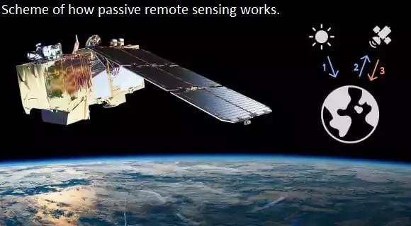
Types Of Remote Sensing - Devices And Their Applications [broad overview]
--
https://eos.com/blog/types-of-remote-sensing/ <-- shared technical article
--
[sharing of this blog post should not be considered an endorsement of this company]
#GIS #spatial #mapping #remotesensing #earthobservation #overview #tutorial #instrumentation #satellite #devices #implementations #radar #laser #sensors #usecase #appliedscience #RADARSAT #TerraSARX #SRTM, #EOSDA #ERS #Sentinel #LANDSAT #insar #ifsar #LiDAR
Genesis - A Flying Observatory To Measure Earth Down To The Millimetre [earth observation satellite]
--
https://www.esa.int/Applications/Satellite_navigation/Genesis <-- Genesis home page
--
https://doi.org/10.1186/s40623-022-01752-w <-- white paper
--
#GIS #spatial #mapping #GNSS #earthobservation #satellite #remotesensing #precision #accuracy #genesis #millimetre #earthobservatory #geodetic #InternationalTerrestrialReferenceFrame #ITRF #planning #spacecraft #Galileo #GPS #usecase #appliedscience #infrastructure #positioning #navigation #earthscience #satnav #referencesystem #geoid #coordinatesystem
@ESA
The Rise Of AI Meets The Golden Age Of Geography [GeoAI overview]
--
https://www.forbes.com/sites/esri/2024/03/22/the-rise-of-ai-meets-the-golden-age-of-geography/ <-- shared media article
--
#GIS #spatial #mapping #overview #summary #GeoAI #AI #artificialintelligence #usecase #appliedscience #spatialanalysis #spatiotemporal #realtime #business #economics #routing #naturalsystems #transportation #waterways #dredging #decisionmaking #prediction #automation #precision #speed #efficiency #scaling #supplychain #assestmanagement #demographics
USGS and Australia To Continue Partnership in Landsat Next Satellite Mission
--
https://www.usgs.gov/news/featured-story/usgs-and-australia-continue-partnership-landsat-next-satellite-mission <-- shared press release
--
https://www.linkedin.com/posts/gregcocks_gis-spatial-mapping-activity-7175533055325962240-H4Kt <-- link to post with resources about Landsat Next
--
#GIS #spatial #mapping #remotesensing #earthobservation #monitoring #satellite #Landsat #LandsatNext #planning #global #imagery #visualisation #spectral #usecase #appliedscience #economicimpact #economicvalue #value #costbenefit #multispectral #synoptic #natural #humanimpact #australia #cooperation #agreement
U.S. Geological Survey (USGS) | NASA - National Aeronautics and Space Administration | NASA Goddard Space Flight Center | Geoscience Australia
Landsat Next – Satellites Offers Improved Data To Earth
--
https://doi.org/10.3133/fs20243005 <-- link to USGS fact sheet 2024-3005
--
https://landsat.gsfc.nasa.gov/satellites/landsat-next/ <-- NASA page
--
https://www.usgs.gov/landsat-missions/landsat-next <-- USGS page
--
https://youtu.be/339KeL29tig?si=kr9asLJS5MeHZg5Z <-- NASA Goddard overview video
--
“With a trio of smaller satellites that can each detect 26 wavelengths of light, the Landsat Next mission is expected to look very different from its predecessors that have been observing Earth for 50 years. This new plan for Landsat Next, a joint mission of NASA and the U.S. Geological Survey, is designed to provide more frequent, and finer resolution, data of the changing surface of Earth…”
#GIS #spatial #mapping #remotesensing #earthobservation #monitoring #satellite #Landsat #LandsatNext #planning #global #imagery #visualisation #spectral #usecase #appliedscience #economicimpact #economicvalue #value #costbenefit #multispectral #synoptic #natural #humanimpact
@USGS @nasa @NASAGoddard @USGSEROS
New Geospatial Data Startup Streamlines Satellite Imagery Visualization
--
https://techcrunch.com/2024/03/05/new-geospatial-data-startup-streamlines-satellite-imagery-visualization/ <-- shared media article
--
[sharing of this article is of course not an endorsement]
#GIS #spatial #remotesensing #processing #servers #datastorage #dataprocessing #middleware #earthobservation #spatialdata #alldataisspatial #imagery #visualisation #startup #Fused #spatialanalysis #usecase #appliedscience #ai #datavisualisation #businessmodel #serverless #industry #commercial #api #gateway #satellite


